Geography
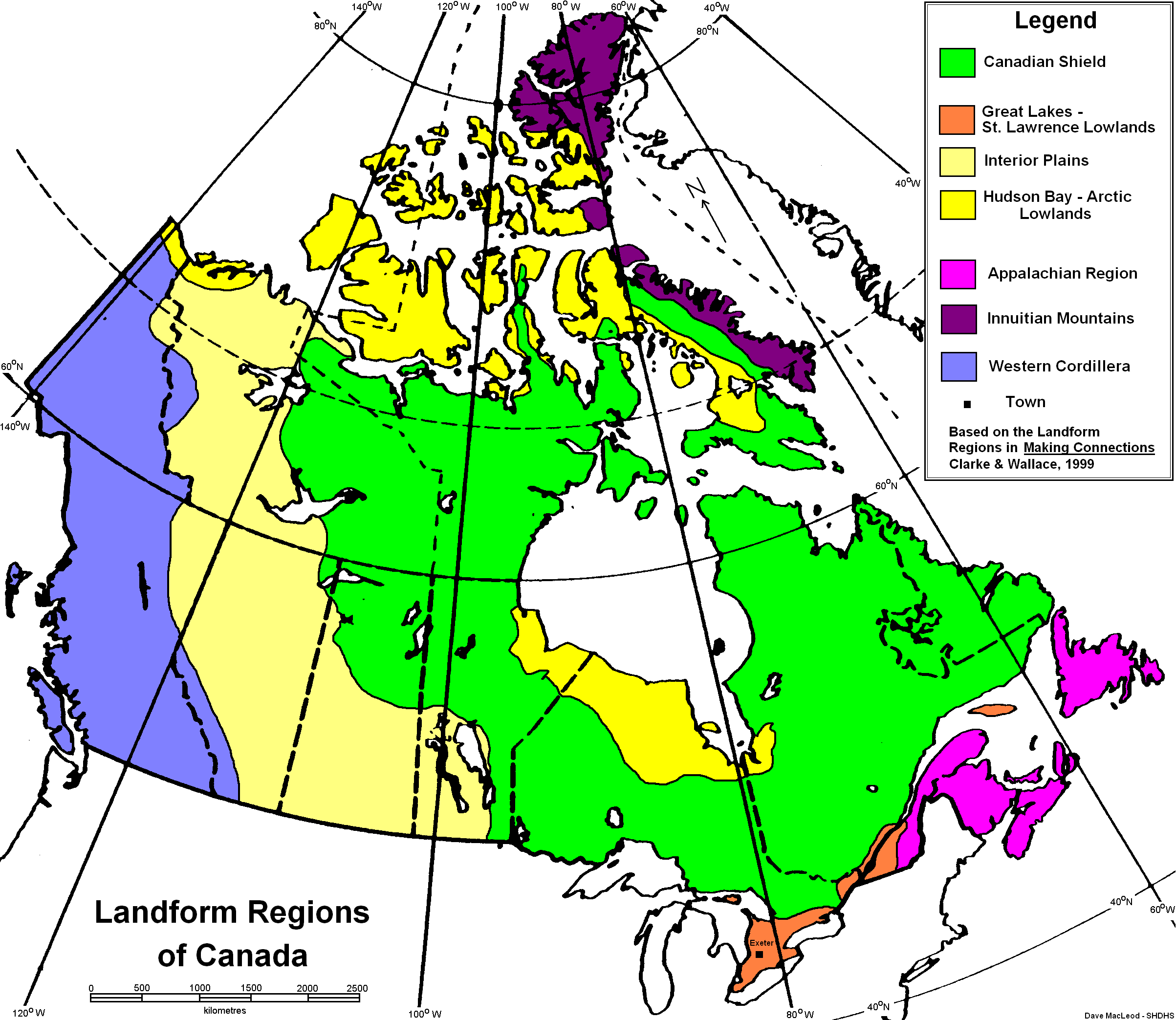
The pastel blue-purple on the left side of the picture is the Cordillera
The Cordillera is a landscape shaped by, erosion, uplift, lava, river erosion and glaciation. The two mountain chains, Coastal and Rocky, were both formed by the collision of two tectonic plates.
Climate
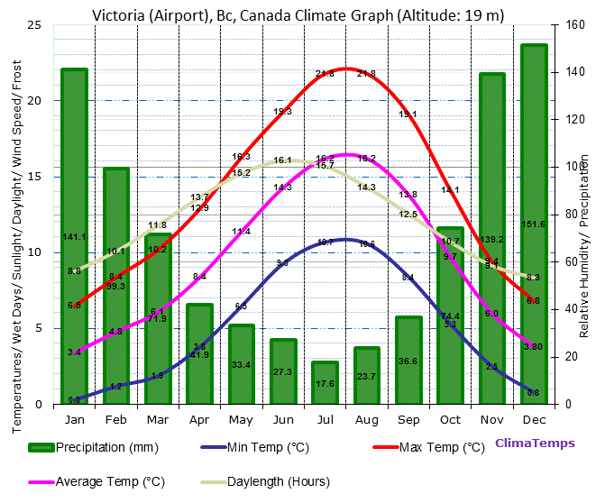
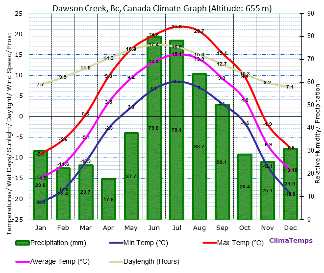
In the nothern the average temperature is 0.5 degrees Celsius and in the southern region it is 7.5 degrees Celsius. It gets dry summers and wet winers. The western side of the coastal mounatins receives 1200-1500mm of precipition per year, while just ot the east of the mountains, the area gets 300mm in the south and 500-800mm in the north. Ther is very diverse soil that can be found in this region, ranging from very dry in the interior to extremely we and moist down in the Lower Mainland.
Climate change has effected the region by making the Alpine Tundra disappear, which is due to rising temperatures and different trees being able to survive in higher elevations.

Vancouver Climate Graph
Vicotria Climate Graph
Dawson Creek Climate Graph
Flora and Fauna
There is a wide variety of organisms present in the Cordillera. Some plants are alpine fir trees, sagebrush, Rocky Mountain Cedar, western hemlock and the western white pine. There is a lot of biodiversity in animals because of the different climates within the region. Caribou, white tailed deer, mountain goat, black bear, grizzly bear, beaver, red tailed fox, coyote, long-eared owl, burrowing owl, black billed magpie, Canada Goose, bald eagle and chipmunk are just a few examples of what can be found there.

Canada Goose
Human Geography
There are different sections of the Cordillera. In the Montane Cordillera, there are 873 498 people and 184 people per 100 square kilometers. In the Arctic Cordillera, there are 1293 people and 0.6 people per 100 square kilometers. The major cities are Vancouver, Victoria and Dawson. Humans use the land for cattle grazing, forestry, mining and tourism.
Economy
The economy in the past largely came form the gold rush, agriculture and trading. Presently, the economy is based aorund forestry, fishing, mining (coal, copper, gold, silver, lead and zinc), oil, hydro, and agriculutre. Agriculture is a large part of the economy in the Interior and Okanagan, which grow lots of fruit and vegetables. The largest export for the Okanagan is wine.
Environmental Concern
The largest environmetnal concern for the Cordillera is the introduction of oil pipelines and oil tankers, in particular, the Enbridge pipeline running from Alberta to Kitimat, BC. They claim their pipelines are safe however they have have had several environmentally devastating spills. The proposed pipeline would carry oil 1170 kilometers, meaning there is a large area for leakage and potential habitat detruction. Two ways of stopping the pipeline is to sign the online petition and tell the local member of parliament you do not support the pipeline.
Comparison
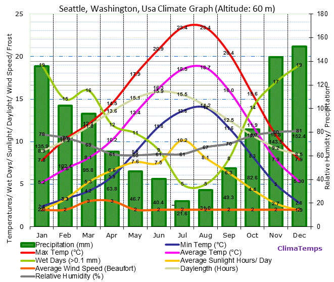
A similar city to Vancouver, BC is Seattle, WA. They are both in the same biome, which means they have similar climate, vegetation, flora and fauna. Seattle's economy is based around fishing, aerospace, information communication technology and health care.
Vancouver Climate Graph
Seattle Climate Graph
No comments:
Post a Comment