Friday 10 June 2016

References

Research

"What You Can Do." • Saskatchewan Eco Network. N.p., n.d. Web. 10 June 2016.


"Plants of the Prairies Ecozone." Plants of the Prairies Ecozone. N.p., n.d. Web. 10 June 2016.


"Canadian Biodiversity Web Site." Canadian Biodiversity Web Site. N.p., n.d. Web. 10 June 2016


"Canadian Biodiversity Web Site." Canadian Biodiversity Web Site. N.p., n.d. Web. 10 June 2016.


Hudson Plains Ecozone. (n.d.). Retrieved June 10, 2016, from http://www.ecozones.ca/english/zone/HudsonPlains/index.html


Hudson Bay lowlands succumbing to warming, climate change. (2013). Retrieved June 10, 2016, from http://www.rcinet.ca/en/2013/10/10/hudson-bay-lowlands-succumbing-to-warming-climate-change/


Physiographic Regions. (n.d.). Retrieved June 10, 2016, from http://www.thecanadianencyclopedia.ca/en/article/physiographic-regions/


Common menu bar links. (n.d.). Retrieved June 10, 2016, from http://www.pc.gc.ca/eng/docs/v-g/nation/sec4.aspx


(n.d.). Retrieved June 10, 2016, from http://www.britannica.com/


Air. (n.d.). Retrieved June 10, 2016, from https://www.ec.gc.ca/Air/default.asp?lang=En


Natural Regions. (n.d.). Retrieved June 10, 2016, from http://www.thecanadianencyclopedia.ca/en/article/natural-regions/


Regional Overview. (n.d.). Retrieved June 10, 2016, from http://www.nrcan.gc.ca/environment/resources/publications/impacts-adaptation/reports/assessments/2008/ch3/10331


 Species and ecosystem impacts. (n.d.). Retrieved June 10, 2016, from http://www.davidsuzuki.org/issues/climate-change/science/impacts/species-and-ecosystems/

Canadian Shield. (n.d.). Retrieved June 10, 2016, from http://www.newworldencyclopedia.org/entry/Canadian_Shield

Great Lakes Region. (n.d.). Retrieved June 10, 2016, from http://www.regions.noaa.gov/great-lakes/index.php/great_lakes-restoration-initiative/invasive-species/

Canadian Regional Geography - Your Canada. (n.d.). Retrieved June 10, 2016, from http://yourcanada.ca/geography/regional/

Common menu bar links. (n.d.). Retrieved June 10, 2016, from http://www.pc.gc.ca/eng/docs/v-g/nation/nation76.aspx

Great Lakes Weather and Climate - Transition Seasons Summary. (n.d.). Retrieved June 10, 2016, from https://www.ssec.wisc.edu/sose/glwx/glwx_module3_summary.html

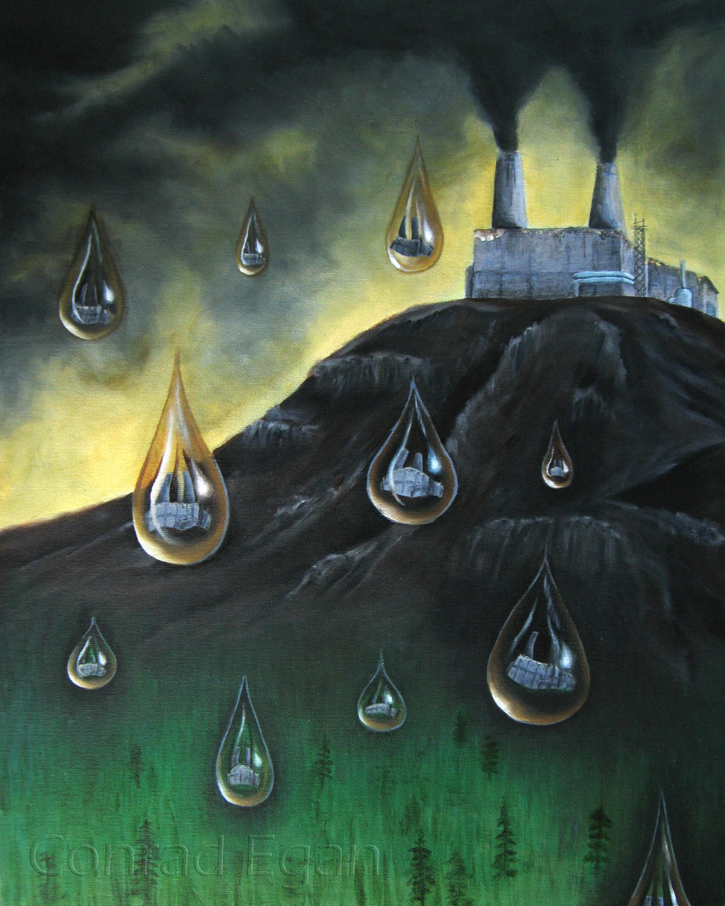
Plundering Appalachia - The Tragedy of Mountaintop-Removal Coal Mining :: The Issue. (n.d.). Retrieved June 10, 2016, from http://www.plunderingappalachia.org/theissue.htm

 Appalachia's Economy. (n.d.). Retrieved June 10, 2016, from http://www.arc.gov/appalachian_region/appalachiaseconomy.asp

Appalachian Mountains. (n.d.). Retrieved June 10, 2016, from http://www.newworldencyclopedia.org/entry/Appalachian_Mountains

A Century of Climate Change-How the Complex Landscape of the Appalachian Forests Will Fare. (2015). Retrieved June 10, 2016, from http://www.sciencetimes.com/articles/5328/20150403/a-century-of-climate-change-how-the-complex-landscape-of-the-appalachian-forests-will-fare.htm

Mountain Soil Types. (n.d.). Retrieved June 10, 2016, from http://www.gardenguides.com/129371-mountain-soil-types.html 

 Images

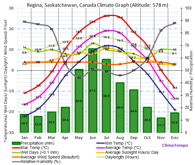
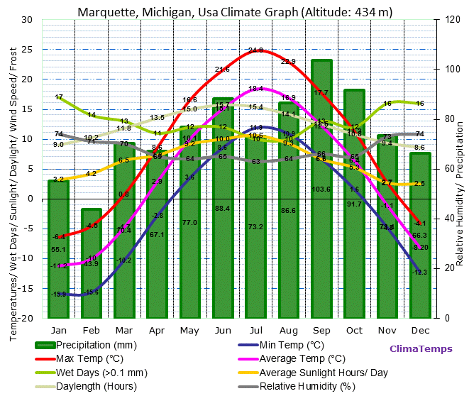
All Climate Graph's sourced from Climatemps.com ---

 World Climate & Temperature. (n.d.). Retrieved June 10, 2016, from http://www.climatemps.com/

Western Cordillera Landform Region. (n.d.). Retrieved June 10, 2016, from http://westerncordilleralandformregion.blogspot.ca/

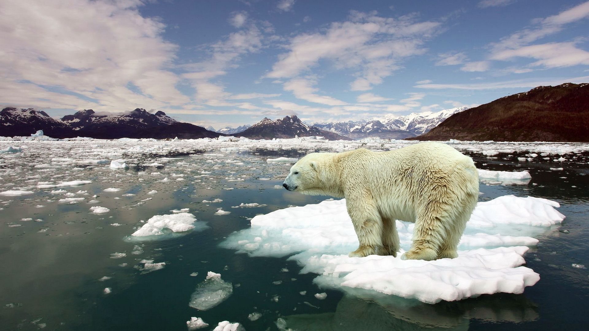
All Animal Pictures From---  Pictures of Animals. (n.d.). Retrieved June 10, 2016, from http://a-z-animals.com/animals/pictures/


Arctic Land

Geography
The Arctic region is represented by the dark purple at the top of the map and the yellow just below it

  The Artic Land is comprised of Palaeozoic and Mesozoic sedimentary rock, and is mostly flat or rolling terrain. The plains may extend for several kilometers inland form the coast, and are still somewhat covered by glaciers.The continent is now rising after being pushed down by glaciers during previous ice ages. The topography is made from past glaciation and the melting of ice. 

Climate

  The Arctic is truly a polar climate, in the north, night lasts 24 hours for three to four months and in the summer the sun doesn't set for the same amount of time.The average annual temperature is -20 degrees Celsius in the north and -6 degrees Celsius in the south, however, temperatures can reach as low as -50 degrees Celsius. The annual precipitation is low, with 400mm on southern Baffin Island to less than 100mm on Central Ellesmere Island. 
  Climate change will effect the RE by reducing sea ice, glaciers retreating and thinning, temperature increasing  and preciptation increases. 
Iqaluit Climate Graph
Cape Dorset Climate Graph
Hall Beach Climate Graph

Flora and Fauna

  In this region, trees are absent and the only vegetation that growa there are dwarf shrubs, forbs, sedges, grasses, mosses and lichens. They have adapted by not needing much precipitation to live, and this region, liquid preciptation is rare. 
  20 species of land mammals live on the archipelago. An example is the peary caribou, which are smaller and lighter in colour than those in the southern regions. This allows them to blend into snow better and get into small places. There are also muscox, arctic foxes, arctic wolves, arctic hares and polar bears. Walruses, seals and whales, such as the narwhal and beluga can be seen in the ocean. There is also an estimated 700 different species of arthropods in the region!
Narwhal

Human Geography

  The Arctic is home to around 100 000 Canadians, 80% of which are First Nations. In the northern Arctic there are 1.7 people per 100 square kilometers and in the south there are 2.3 people per square kilometers. Humans use the land to gather things to survive, to mine and extract various resources. 
Economy

  The past economy of the regoin included whale and seal hunting, the fur trade and mining. Presently the economy is largely, oil mining and diamond mining. The diamond industry is expected to bring 4 million caratsof diamonds a year for seventeen years, and have 830 permanent employees. The harsh, fragile environmetn of the Arctic obstructs there from being any development of resource industries, settlement or economic expansion. 

Environmental Concerns

  The largest environmental concern is that of global warming. The Arctic is the first region to feel the effects of climate change. They have already felt reduced sea ice, glaciers retreating and thinning, temperature increases and precipitation increases. Climate change is directly sourced from the emission of fossil fuels throughout the world, and the best route to stopping it is to reduce or stop the burning of fuels. Another great way of regulating the use of fossil fuels is to improve the insulation in homes, to improve temperature consistancy and not having to burn more fuel to keep a house warm. 
Global warming in the Arctic
Comparison


  A similar region is that of Palmer, Antarcica, which is in the arctic biome as well and experiences similar climate. Palmer, Antarctica is a United States research centre, so the only ecomony is that which it bring to the United States. 
Temperature at south pole (no data for anywhere other than that)

Iqaluit Climate Graph


Interior Plains

Geography

The Interior Plains is represented by the light yellow-taupe colour next to the blue Cordillera.

  The Interior Plains is distinguished by its vast expanses of sedimentary bedrock and very flat land that stretches for kilometers. The small-scale features are a result of Quaternary Glaciation, which is 2.6 million to 10 000 years of age. The topography is partly from flat-lying limestones and shales or marine origin underlying the entire region. Erosion and uneven uplift has resulted in the carving of the western part into isolated uplands. 

Climate

  There are extreme differences in temperature between day and night, and the seasons. The average winter temperature is -15 degrees Celsius to -26 degrees throughout the region, and the average summer temperature is 15 degrees Celsius. The region can experience extreme weather conditions such as extremely cold winters due to being so far away from the ocean, where the climate would be regulated. The area does not get enough rain for a large diversity of crops, and they can get very powerful storms. Although the Rocky Mountains block most of the rain, agriculture can still thrive in the vertisolic soils. 
Calgary Climate Graph

Regina Climate Graph

Saskatoon, Saskatchewan Climate Graph
Saskatoon Climate Graph

Flora and Fauna


  The Plains are a great place to go for animals if they are looking to breed. For example, over half of North American ducks are born there because the wetlands are a great breeding place for them. They migrate every year using the Central North American Fly Way. Other animals include, squirrels, antelope,coyote, bison, deer and white-tail jackrabbits. 

 There is a greater diversity of plants on the Eastern side however the whole region contains many variety. Some are prairie sage, saskatoon berries, spear grass, wheat grass and willow trees. 

Willow Tree

Human Geography

  The population of the Interior Plains used to be around half rural and half urban, but in recent years, the urban population shot up to 81% of all Plain's residents. The largest cities are Calgary, Edmonton, Regina, Saskatoon and Winnipeg. The total population is almost six million people. The population use the land for agriculture and oil exraction.
Population Density of Canada
Economy

  The past economics of the region were largely based off of the Fur Trade, Bison Hunt and agriculture. Agriculture is still a large part of the economy and farmers grow canola, beans, carrots, wheat and barely, as well as many others. However, since the opeing of the Leduc Oil Field in 1947, the petroluem industry has been dominating. Some of the large companies in the area are Petro-Canada and Husky Oil. The oil sands have also been a large contributer, specifically the ones near Fort McMurray. 

Environmental Concerns

  A porblem that has come to light in Saskatchewan is the use of pesticides, and how they are linked to serious health conditions. Pesticides are used in farming, in cities and in personal gardens, however people may not know that there are links between pesticides and solid tumors, brain cancer, prostate cancer, kidney cancer, pancreatic cancer, leukemia and nervous system damage. Not to mention the environment damage pesticides cause, getting rid of "pests" also contaminates soil, water and air. The best way to eliminate this problem is to stop the use of pesticides and being okay with eating a grape with a hole in it, or a potato with a few pecks. 

Comparison

  
  A similar location to that of the Interior Plain's is Sochi, Russia. The two have very similar high and low temperatures, but Sochi doesn't get nearly as cold. Sochi actually just got over an economical crisis after the 2014, Winter Olympics. It took so much money to build and prepare, and they didn't make as much as was expected once the games came.

Calgary Climate Graph

Temperature Graph of Sochi

Precipitation Graph of Sochi

Cordillera

Geography
  The pastel blue-purple on the left side of the picture is the Cordillera

  The Cordillera is a landscape shaped by, erosion, uplift, lava, river erosion and glaciation. The two mountain chains, Coastal and Rocky, were both formed by the collision of two tectonic plates. 

Climate

  In the nothern the average temperature is 0.5 degrees Celsius and in the southern region it is 7.5 degrees Celsius. It gets dry summers and wet winers. The western side of the coastal mounatins receives 1200-1500mm of precipition per year, while just ot the east of the mountains, the area gets 300mm in the south and 500-800mm in the north. Ther is very diverse soil that can be found in this region, ranging from very dry in the interior to extremely we and moist down in the Lower Mainland.
  Climate change has effected the region by making the Alpine Tundra disappear, which is due to rising temperatures and different trees being able to survive in higher elevations.
Vancouver Climate Graph
Victoria (Airport), Bc Climate Graph
Vicotria Climate Graph
Dawson Creek, Bc Climate Graph
Dawson Creek Climate Graph

Flora and Fauna

 There is a wide variety of organisms present in the Cordillera. Some plants are alpine fir trees, sagebrush, Rocky Mountain Cedar, western hemlock and the western white pine. There is a lot of biodiversity in animals because of the different climates within the region. Caribou, white tailed deer, mountain goat, black bear, grizzly bear, beaver, red tailed fox, coyote, long-eared owl, burrowing owl, black billed magpie, Canada Goose, bald eagle and chipmunk are just a few examples of what can be found there. 
Canada Goose

Human Geography


 There are different sections of the Cordillera. In the Montane Cordillera, there are 873 498 people and 184 people per 100 square kilometers. In the Arctic Cordillera, there are 1293 people and 0.6 people per 100 square kilometers. The major cities are Vancouver, Victoria and Dawson. Humans use the land for cattle grazing, forestry, mining and tourism.


Economy

  The economy in the past largely came form the gold rush, agriculture and trading. Presently, the economy is based aorund forestry, fishing, mining (coal, copper, gold, silver, lead and zinc), oil, hydro, and agriculutre. Agriculture is a large part of the economy in the Interior and Okanagan, which grow lots of fruit and vegetables. The largest export for the Okanagan is wine. 

Environmental Concern

  The largest environmetnal concern for the Cordillera is the introduction of oil pipelines and oil tankers, in particular, the Enbridge pipeline running from Alberta to Kitimat, BC. They claim their pipelines are safe however they have have had several environmentally devastating spills. The proposed pipeline would carry oil 1170 kilometers, meaning there is a large area for leakage and potential habitat detruction. Two ways of stopping the pipeline is to sign the online petition and tell the local member of parliament you do not support the pipeline. 

Comparison

  A similar city to Vancouver, BC is Seattle, WA. They are both in the same biome, which means they have similar climate, vegetation, flora and fauna. Seattle's economy is based around fishing, aerospace, information communication technology and health care.
Vancouver, British Columbia Climate Graph
Vancouver Climate Graph

Seattle, Washington Climate Graph
Seattle Climate Graph

Thursday 9 June 2016

Hudson Bay Lowlands

Geography

The Hudson Bay Lowlands are the bright yellow that is located just under the Hudson Bay. 

  The entire Hudson Bay Lowlands gradually slopes toward the Hudson Bay at a gradient of less than one metre per kilometre. Around 85% of the region is wetlands, and there is seemingly more water than earth. The water can be found in the form of lakes, rivers, bogs and fens. Water in the form of permafrost underlies most of the region, and in the summer it thaws and invites many biting bugs. The Big semi-circle of the Hudson Bay was suggested to be caused by a massive meteor strike. The bedrock terrain is completely masked by a mantle of glacial and marine sediments from the advance and retreat of ice during the last glaciation. There are parallel gravel beach ridges that were caused by storm waves thrown up during the last 5000-6000 years, as the sea level fell in response to rapid uplift of the Earth Crust. 
Hudson bay Lowlands landscape

Climate

  The daily temperature in July ranges from 12 degrees Celsius to 16 degrees Celsius, and in January, it is from -25 degrees Celsius to -23 degrees Celsius. The average annual precipitation is 500mm to 700mm per year, and that number is lower in the northern area. There are web-like or polygon shapes in the soil, and the soil also has very poor drainage which results in the wetlands and abundance of insects in the summer. Climate change will effect the region by making the winters shorter and have shorter periods of ice cover. The harmer temperatures mean more evaporation and lower water levels. 
 
Churchill climate graph

Mossonee climate graph

Thompson climate graph

Flora and Fauna

  The Vegetation of the Hudson Bay Lowlands follows two basic patterns; north to south ans altitude. North to south it starts really bare and treeless in the tundra, but moving south into the Taiga more, trees appear. The altitude pattern results in belts of trees, because the trees can only grow in the northern region due to the poor drainage of the soil . Some species of trees that can be found are black spruce, white spruce, tamarack, balsam poplar and dwarf birch. 
  The highest diversity of animals can be found in the summer when migrating birds come to breed and the insects come out. It is estimated that a single hectare can produce up to ten billion black flies. The birds have adapted to their environment by leaving for the cold winter, and coming back when the climate is more suitable. Some mammals that live there are caribou, deer, moose, bears, snowshoe hares, beavers, red foxes, minks, seals and belugas. 

Snowshoe hare

Human Geography

  Only 0.04% of Canada lives in this region with a population of 10 000 people in all of the Hudson Bay Lowlands. There are approximately 2.7 people per 100 square kilometers. People use the land for tourism, fishing, hunting and trapping. The major cities are Churchill and Moosonee. 

Economy

  Similar to the Canadian Shield, the Hudson Bay Lowlands' economy is heavily based off of mining. Being around the Hudson Bay, this region was prime for fur trapping and it became the prime economic activity. Forestry isn't important here since there aren't any rich forests to harvest, and the soil does not drain well so agriculture is not an industry here either, The region has many mines and smelters, ranging from nickel, copper and gold mines to an aluminium smelter.


Environmental Concern

  A major concern for environmentalists is the rapid increase in temperature of the Hudson Bay since the 1990's. In the past, icebergs in the bay would keep the bay cold, but it reached its limit and the temperature has been rising for the past twenty years. This is a result from the rising global temperature that can be felt throughout the world. A way to stop global warming is to reduce carbon emissions and pollution being pumped into the air, however, people have been talking about doing this for quite sometime and nothing has changed. Perhaps looking at another method would work easy due to this one not taking effect. 

global warming image


Canadian Shield Forest Land

Geography

The Canadian Shield is represented by the neon green colour covering most of Canada.

  The Canadian Shield covers five million square kilometres. It is made up of pieces of the Earth's crust which began colliding together more than three billion years ago through plate tectonics. Repeated glacial advancements have left many lakes, streams, rivers and ponds, such as Great Bear Lake, Great Slave Lake, Lake Athabasca and many more. Some of the areas oldest rocks were found near Great Bear Lake. 

Climate

  Due to the large size of the Shield, the climate varies depending on which area you are in. In the southern parts they have a seasonal climate with an average winter temperature of -18 degrees Celsius, and an average summer temperature of 25 degrees Celsius. In the northern region, there is an average winter temperature of -35 degrees Celsius, and an average summer temperature of 15 degrees Celsius. Precipitation can range anywhere from 400 mm a year to 1600 mm a year, depending on position to large water bodies. 
  The lowlands have soggy soil that it suitable for planting trees and there are many marshes and bogs. However, the rest of the region has very coarse soil that does not hold moisture well and is frozen year-round. 
  Climate change will effect the region by increasing how many forest fire there are, increasing the already one million hectares to three million hectares. 
Thunder Bay, Ontario Climate graph

Cambridge Bay, Nunavut Climate graph

Iqualuit, Nunavut Climate graph

Flora and Fauna

  In the south, the Canadian Shield is a vast boreal forest containing many trees such as white spruce, black spruce, balsam fir, balsam poplar, red pine and white pine. The animals of the southern range from large herbivores specifically, caribou, deer and moose to large carnivores for example, bears, lynx, bobcats and wolves. Small animals like squirrels, chipmunks, hares, beavers and porcupines are also present, as well as, whales and seals off the east coast. 
Moose

Canadian Shield Boreal Forest
  
 The transition between between the tundra and boreal forest is called the Northern Canadian Shield Taiga eco-region and it is characterized by low lying bushes. The bushes are very low because of the harsh winds keeping them low to the ground. 

Human Geography

  Since the northern region of the Canadian Shield has gruelling conditions, people tend to stick to the southern areas where it is warmer. There are 2 people per square kilometre in the cities and less than 0.5 people per square kilometre everywhere else. Inhabitants use the land for forestry, mining, hydroelectric power and recreational sources. Some of the major cities in the lower region are Sudbury, Chicoutimi and St. John's. In the Taiga, the major cities are Yellowknife,  Labrador City and Churchill Falls. 
Population density map of Canada. 

Economy


  Canada's largest economic region is the Canadian Shield, as it covers most of Canada's land. In the past, the most dominant economics activity was the fur trade. Forestry was large as well as mining, which are both still prevalent today. 
  Many mines are stationed in the region, accompanying many mining companies that started up in the region. Some elements that are largely mined are, aluminium, iron, nickel, copper and silver. Two global mining companies that are recognized worldwide are Inco and Alcan.
Inco mining company logo

Alcan mining company logo

  The Shield's many rivers also opened up the opportunity for hydroelectric power, which soon developed after Confederation. 

Environmental Concerns

  A large problem for most of Eastern Canada is Acid rain, and it is now a problem in the Canadian Shield. 
  As emissions of sulphur dioxide and nitrogen oxides transform into secondary pollutants, they are removed from the atmosphere (their presence makes the pH scale of the acids in it over 5.6) in the form of rain, snow, steel or hail. 
  This is a problem in the Canadian Shield because the lakes and rivers lack natural alkalinity, and therefore cannot neutralize the water naturally as some other regions can. One way of stopping the fall of acid rain is to reduce emissions of the toxins that cause it. This has been the solution for many environmental problems, however most of the population is not open to the idea since it is so integrated into society.

Illustration of acid rain 

Comparison
  
One comparison is that between Moscow and Yellowknife. Although Moscow receives more precipitation, they have very similar maximum temperature, number of wet days, humidity and minimum temperature. In Moscow, women make up more than half of the work force. Major industries are, engineering, manufacturing, food processing and furniture making. Some of Moscow's major exports are, metals, wood and oil. 

Moscow climate graph


Yellowknife climate graph


Tuesday 7 June 2016

St. Lawrence Lowlands

Geography
The St. Lawrence Lowlands are the peachy-orange colour in the bottom left.

 The unique geography of the St. Lawrence Lowlands was shaped by glaciation, marine submergence, river erosion and river deposition. Weathering and deposition of river gravels was soon followed by at least two episodes of glaciation. The last major glacial advance was 18 000 years ago and was followed by the land rising as much as 20 meters per century starting from 13 000 to 10 000 years ago. 
  Altitudes range from 15 meters above sea level along the St. Lawrence River to 150 meters along the borders with the Laurentian mountains. 


Climate

In the Great Lakes area, the wet season is the summer months, however the region still receives a steady amount of precipitation throughout the year. The lakes serve as "heat sinks" that moderate the temperatures of the surrounding land. They also act as a giant humidifier, increasing the moisture in the air and causing heavy snowfall in the winter and heavy rainfall in the summer.
Toronto Climate Graph

Quebec City Climate Graph

Montreal Climate Graph

 The soil has a lot of clay deposited in it from the Champlain Sea and can be as thick as 60 meters along the north side near the former glacier margin. Around the margins of the Lowlands there are also many sand and gravel beaches.
  Climate change is being felt throughout the world in various ways, and in the St. Lawrence Lowlands, they will see a decline in annual and spring snow/rainfall. They will also be experiencing many drought episodes.

Flora and Fauna
  The Great Lakes area has a large biodiversity as there are many different ecosystems within it. Some trees include, sugar maple, American beech, basswood, white oak, red oak, shagbark hickory, bloack wood and butternut. 
  Some recent animal arrivals are white tailed deer, grey squirrels, coyote, starlings, house sparrows and ringbilled gulls. 
  All species that thrive in this area must be able to also adapt to agricultural crops and suburban habitats. 
White tailed deer 

Human Geography

 This area is the largest inhabited in Canada. Early settlement was mostly in this area and ever since Europeans came over, this region has seen a high density of people. The largest cities are Toronto and Montreal. Fifty percent of Canadians live here and they produce seventy percent of Canada's manufactured goods. 
  It is known as the industrial centre of Canada, for this is where the first major industries and factories were built. The people use the land for agriculture, and farming grapes, peaches, pears and maple syrup from the sugar maple trees. 

Economy

  This area has been the powerhosue of Canada since Confederation. Before Confederation, settlers traded fur, farmed and harvested lumber. However as economics advanced, so did the economy and manufacturing, saw mills, beweries, iron and steel factories and even an oil refinery were developing. Today, the economy of the St. Lawrence Lowlands is still largely manufactuing based, with companies such as Northern Telecom, one of the world's leading telecommunication industires. This region is the highest financial region of Canada, for many large companies such as Bell, Northern Electric and most of Canada's banks having their head offices located there. Much of this region has been industrialized, urbanized, covered in industrial waste and covered in smog, resulting in not much use of the land. 
Environmental Concerns

  One of the major environmental concerns is the decline in bio diversity and rising of invasive species. 
  Invasive species are a species not native to a specific environment, and which have a tenancy to wreck havoc in their introduced environment. Some invasive species to the St. Lawrence Lowlands are the zebra mussel, the quagga mussel, round goby, the sea lamprey and the alewife fish. Common invasive species are purple loosestrife and Eurasian Milfoil, which have caused lots of damage in the Great Lakes. 
  It is very had to control a species once it is established, so the most cost-effective manner of dealing with them is just educating people about how to stop spreading them and various other ways of prevention. However, many people don't care about invasive species and dumping random things into habitats. Many organizations are working towards educating more people and putting up more signs, not just in the St. Lawrence Lowlands but also throughout the world.

Alewife Fish

Comparison


  One place that is very similar to the St. Lawrence Lowlands is Marquette, Michigan. It is in the same region, however it is outside of Canada and there are differences in economy, politics and human geography. Michigan's economy is largely based off of the manufacturing of goods, but also a little of mining and logging. 
Marquette Climate Graph

Toronto Climate Graph